
Choose Your Language
Rivers are not just water bodies—they are lifelines of civilizations, crucial for agriculture, economy, culture, and biodiversity. For aspirants preparing for government exams like UPSC, SSC, RRB NTPC, CDS, and State PSCs, questions related to Indian rivers frequently appear in General Studies, Environment, and Geography sections. This detailed blog covers everything you need to know: classification, origins, tributaries, river valley projects, importance, and exam-focused facts.
- Classification of Indian Rivers
- Major Himalayan River Systems
- Major Peninsular River Systems
- Major River Valley Projects and Dams (Frequently Asked)
- Importance of Rivers in India
- Exam-Oriented Key Facts
- Quick Revision Tricks
- Most Common Previous Year Questions (PYQs)
🧭 1. Classification of Indian Rivers
A. Based on Origin
- Himalayan Rivers
- Originate from snow-covered mountains or glaciers
- Perennial in nature: flow throughout the year
- Form meanders, flood plains, and deltas
- E.g.: Ganga, Yamuna, Brahmaputra
2. Peninsular Rivers
- Originate from Western Ghats or central highlands
- Mostly seasonal: dependent on rainfall
- Flow through plateaus and form deep valleys
- E.g.: Godavari, Krishna, Narmada, Mahanadi
B. Based on Direction of Flow
- East-flowing Rivers – Drain into the Bay of Bengal (e.g. Ganga, Godavari, Mahanadi)
- West-flowing Rivers – Drain into the Arabian Sea (e.g. Narmada, Tapi, Mahi)
🌊 2. Major Himalayan River Systems
A. Ganga River System
- Origin: Gangotri Glacier in Uttarakhand (as Bhagirathi)
- Confluence at Devprayag: Bhagirathi + Alaknanda → Ganga
- Length: Approx. 2525 km
- States: Uttarakhand, Uttar Pradesh, Bihar, Jharkhand, West Bengal
- Mouth: Bay of Bengal (forms Sundarbans Delta)
- Left Tributaries: Yamuna, Gomti, Ghaghara, Gandak, Kosi
- Right Tributary: Son
- Importance: Cultural symbol, irrigation source, supports dense population
- Note: Sundarbans is the world’s largest delta
B. Yamuna River
- Origin: Yamunotri Glacier, Uttarakhand
- Length: ~1376 km
- Confluence: Joins Ganga at Prayagraj (Triveni Sangam)
- Tributaries: Chambal, Betwa, Ken, Sindh
- Cities Along: Delhi, Mathura, Agra
- Significance: Major water source for northern plains, heavily polluted
C. Brahmaputra River
- Origin: Angsi Glacier, Tibet (as Tsangpo)
- Enters India as: Dihang in Arunachal Pradesh
- Length in India: ~916 km
- Major Tributaries: Dibang, Lohit, Subansiri, Kameng
- Meets Ganga in Bangladesh → Forms Meghna
- Notable Features: Causes annual floods in Assam
- Fact: Home to Majuli Island (world’s largest river island)
🌧️ 3. Major Peninsular River Systems
A. Godavari River
- Origin: Trimbakeshwar (Nashik, Maharashtra)
- Length: ~1465 km (longest in peninsular India)
- Nicknamed: Dakshin Ganga
- States: Maharashtra, Telangana, Andhra Pradesh
- Major Tributaries: Pravara, Purna, Manjira, Indravati, Sabari
- Importance: Supports major agriculture in Deccan plateau
B. Krishna River
- Origin: Mahabaleshwar (Maharashtra)
- Length: ~1400 km
- States: Maharashtra, Karnataka, Andhra Pradesh
- Tributaries: Bhima, Tungabhadra, Musi
- Note: Important for irrigation and hydro projects
C. Narmada River
- Origin: Amarkantak Plateau (Madhya Pradesh)
- Length: ~1312 km
- Drainage: Arabian Sea
- Type: Rift Valley River (flows westward)
- Significance: Forms scenic Dhuandhar Falls, Marble Rocks
- Dam: Sardar Sarovar (Gujarat)
D. Mahanadi River
- Origin: Sihawa Hills, Chhattisgarh
- States: Chhattisgarh, Odisha
- Length: ~851 km
- Tributaries: Seonath, Jonk, Hasdeo, Mand
- Dam: Hirakud Dam (world’s longest earthen dam)
E. Cauvery (Kaveri) River
- Origin: Talakaveri, Karnataka (Western Ghats)
- Length: ~800 km
- States: Karnataka, Tamil Nadu
- Tributaries: Hemavati, Kabini, Amaravati
- Fact: Cauvery water dispute is a major inter-state issue
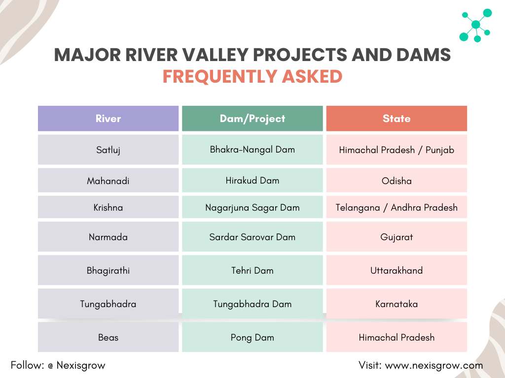
🏗️ 4. Major River Valley Projects and Dams (Frequently Asked)
📚 5. Importance of Rivers in India
- Agriculture: Rivers irrigate vast stretches of land (e.g., Ganga Basin)
- Hydropower: Source for generating electricity (e.g., Bhakra-Nangal, Tehri)
- Drinking Water: Lifeline for millions in rural and urban India
- Cultural/Religious: Ganga, Yamuna, and others are sacred in Indian tradition
- Navigation and Trade: Inland waterways like National Waterway-1 (Ganga)
- Ecological Balance: Maintain aquatic ecosystems and biodiversity
🧠 6. Exam-Oriented Key Facts
- Longest River in India: Ganga (~2525 km)
- Longest Peninsular River: Godavari (~1465 km)
- West-Flowing Rivers: Narmada, Tapi, Mahi
- Largest Delta: Ganga-Brahmaputra (Sundarbans)
- Rivers with Disputes: Cauvery (TN-Karnataka), Krishna (AP-Telangana)
- Perennial Rivers: Himalayan origin (Ganga, Yamuna, Brahmaputra)
- Seasonal Rivers: Peninsular origin (Godavari, Krishna, Mahanadi)
✅ 7. Quick Revision Tricks
- GGBKMK – Major rivers: Ganga, Godavari, Brahmaputra, Krishna, Mahanadi, Kaveri
- “Narmada & Tapi” – West flowing, rift valley rivers
- Triveni Sangam – Confluence of Ganga, Yamuna, and mythical Saraswati at Prayagraj
- Sundarbans – Delta formed by Ganga + Brahmaputra in West Bengal and Bangladesh
🧾 8. Most Common Previous Year Questions (PYQs)
- Which river is called Dakshin Ganga? – Godavari
- Where is Hirakud Dam located? – Mahanadi, Odisha
- Which river forms the Majuli Island? – Brahmaputra
- Which river flows through a rift valley? – Narmada
- Which river joins Ganga at Prayagraj? – Yamuna
Conclusion
For competitive exams, mastering Indian rivers involves more than just memorizing names. You must understand their origin, path, tributaries, associated dams, and relevance to agriculture, ecology, and economy. Use maps regularly, revise static facts with tricks, and stay updated with river disputes or related current affairs.